GEOTECHNICALENGINEERING
KAMLOOPS
HomeIn-Situ TestingField density test (sand cone method)

Field Density Testing – Sand Cone Method in Kamloops

Practical geotechnics, field-tested.

LEARN MORE

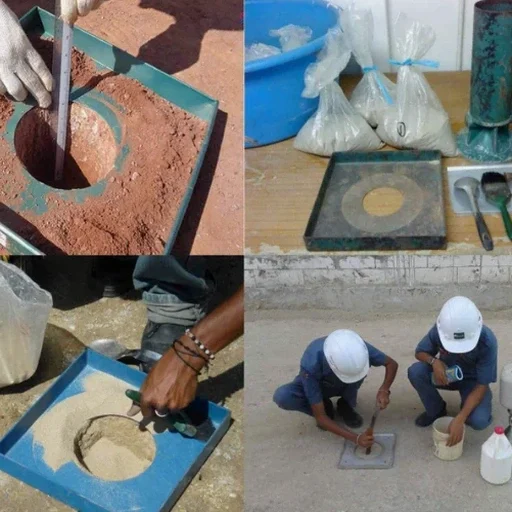
Kamloops grew from a fur trading post into a transportation hub where the North and South Thompson rivers meet, and that expansion pushed development onto a variety of native soils. Glacial till, alluvial deposits, and patches of lacustrine silt all show up within a few kilometres of each other, so compaction verification is not just a box to tick—it becomes a practical necessity on nearly every earthworks job. The sand cone method remains our go-to procedure for field density testing because it is straightforward, reliable, and accepted by every municipality and consulting engineer in the region. When trench backfill goes in along Tranquille Road or structural fill is placed beneath a new warehouse floor on the Tk’emlúps reserve, we set up the apparatus directly on the compacted lift and get a result that reflects what the roller actually achieved. In coarse-graded materials where nuclear gauge readings drift unpredictably, the sand cone gives us a physical measurement that nobody questions during a site review. For projects where deeper stratigraphy matters, we often pair the test with test pits to identify buried organics or loose lenses before compaction begins.

A sand cone test gives you a physical volume and a physical mass—there is no calibration drift to argue about when the inspector shows up.

Our service areas

How we work

The surficial geology around Kamloops is dominated by glacial till with a high percentage of angular clasts and a silt-sand matrix that compacts well but can be moisture-sensitive. During spring freshet, groundwater rises close to the surface in the floodplain between Valleyview and the river, and that extra moisture makes it harder to reach specified density targets with standard effort. We run the sand cone test using Ottawa sand that has been conditioned and calibrated in our lab following ASTM D1556, and we check the calibration cone volume every day before heading to the field. A typical test in a utility trench takes about twenty minutes, including excavation, sieving the removed material, and weighing everything on a portable balance. The density results tie directly to the Proctor curve we develop in the lab, so the contractor knows whether the lift passes or needs another pass with the sheepfoot roller. On larger subdivision projects we often sequence the field density checks with grain-size analysis to confirm that imported fill meets the gradation band specified in the contract documents.
Field Density Testing – Sand Cone Method in Kamloops
Technical reference — Kamloops

Site-specific factors

The contrast between the benchlands above the city and the river-bottom soils along the Thompson is stark, and compaction risks shift accordingly. Up in Aberdeen or Dufferin, the native till is dense and gravelly, so the bigger risk is oversize particles that force us to use a larger excavation volume and apply a rock correction to the density calculation. Down near Riverside Park or the industrial yards east of the Red Bridge, the water table sits high and fine-grained overbank deposits can pump water into the test hole if the excavation is too slow. We have seen compaction percentages drop from 98 to 92 just by moving fifty metres into a wetter lens, which is why we insist on testing density at multiple locations rather than taking one reading and assuming the whole lift is uniform. The biggest error we catch on site is a Proctor curve that does not match the actual material being placed—running a fresh lab compaction test on the same source pit saves more rework than any field procedure adjustment.

Need a geotechnical assessment?

Reply within 24h.

Email: info@geotechnicalengineering.vip

Regulatory framework

ASTM D1556 – Standard Test Method for Density and Unit Weight of Soil in Place by Sand-Cone Method, ASTM D1557 – Standard Test Methods for Laboratory Compaction Characteristics of Soil Using Modified Effort, CSA A23.3 (compaction-related subgrade requirements referenced in concrete code), NBCC 2020 – National Building Code of Canada (earthworks and foundation provisions)

Technical parameters

ParameterTypical value
Test standardASTM D1556 / ASTM D1557 (Proctor reference)
Sand typeGraded Ottawa sand, calibrated daily
Typical test depth150 mm (6 in) per lift
Minimum test frequency1 per 300 m² per lift (or as per project spec)
EquipmentSand cone apparatus, base plate, 10 kg portable scale
Result reportingDry density, wet density, % compaction vs. Proctor
Common fill materials testedGranular borrow, trench backfill, structural fill, subgrade

Frequently asked questions

How much does a field density test using the sand cone method cost in Kamloops?

A single field density test with the sand cone method typically runs between CA$140 and CA$220, depending on travel distance to the site and the number of tests requested in the same mobilization. A full day of testing with multiple lifts and locations usually brings the per-test cost toward the lower end of that range.

How soon can the test be scheduled once the fill is placed?

We can usually mobilize within 24 to 48 hours of a call, and for larger ongoing earthworks projects we coordinate with the site superintendent to have a technician on standby. The test itself takes about twenty minutes on site, and we provide the compaction percentage verbally before leaving so no one waits for a written report to keep working.

What type of fill material is the sand cone method best suited for in the Kamloops area?

The method works well on most compacted soils we encounter around Kamloops, from the gravelly tills in the upper bench areas to the sandier alluvial deposits near the river. It is particularly useful in coarse-grained fills with particles up to about 50 mm, where nuclear density gauges tend to give erratic readings because of voids and irregular surfaces.

Location and service area

We serve projects in Kamloops and surrounding areas.

View larger map